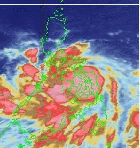
Location of Center:
(as of 10:00 p.m.) 50 kms Southeast of Masbate
Coordinates: 12.1°N, 123.9°E
Strength: Maximum sustained winds of 140 kph near the center
and gustiness of up to 170 kph
Movement: West Northwest at 19 kph
Forecast Positions/Outlook: Tonight:
will cross Masbate then traverse the inland waters of Southern Luzon
Saturday evening:
60 kms Northeast of Metro Manila
Sunday evening:
30 kms South of Laoag City
Monday evening:
110 kms Northwest of Basco, Batanes
Areas Having Public Storm Warning Signal
Signal No.3
(100-185 kph winds) Masbate
Sorsogon
Albay
Burias Island
Catanduanes
Camarines Provinces
Southern Quezon
Marinduque
Romblon
Oriental Mindoro Samar Provinces
Leyte
Biliran Island
Capiz
Aklan
Northern Antique None
Signal No. 2
(60-100 kph winds) Cuyo Island
Calamian Group
Occidental Mindoro
Batangas
Cavite
Laguna
Bulacan
Rest of Quezon
Rizal
Metro Manila Southern Leyte
Northern Cebu
Northern Negros Occidental
Iloilo
Rest of Antique
Signal No. 1
(30-60 kph winds) Nueva Viscaya
Quirino
Aurora
Nueva Ecija
Pangasinan
Tarlac
Pampanga
Zambales
Northern Palawan
Lubang Island Rest of Negros Occidental
Negros Oriental
Siquijor Island
Rest of Cebu
Bohol
Public Storm Signals #1 elsewhere is now lowered.
Residents in low lying areas and near mountain slopes are advised to take all the necessary precautions against possible flashfloods and landslides. Likewise, those living in coastal areas under signal 2 and 3 are alerted against big waves or storm surges generated by this typhoon.
The public and the disaster coordinating councils concerned are advised to take appropriate action and watch for the next bulletin to be issued at 5 a.m. tomorrow.
source: abs-cbn
Linkback: https://tubagbohol.mikeligalig.com/index.php?topic=13475.0
